US DoD protects White House and Capitol with AI air defense system by Teleidoscope
The US Department of Defense (DoD) has installed two AI-powered air defense camera systems from Teleidoscope to protect the National Capital Region (NCR), which includes the White House and US Capitol, from aircraft and drones that have crossed into restricted airspace, also known as the Washington, D.C. Special Flight Rules Area (SFRA), without proper authorization.
The Enhanced Regional Situational Awareness (ERSA) system uses AI-software to automatically detect and track suspicious aircraft even on cloudy days using visual and infrared cameras while alerting operators at the Joint Air Defense Operations Center (JADOC) located at Joint Base Anacostia-Bolling in Washington, D.C.
The system leverages Teleidoscope's proprietary tracking framework called RAD to quickly detect even small birds flying through the field of view and track them with visual target indicators. The laser rangefinder and optical views of the aircraft supplement radar data in deciding an appropriate response. The Teleidoscope system has an eye-safe red-green laser that operators can use to target and dazzle pilots in those aircraft to warn them off.
Teleidoscope was awarded a production contract with a $100 million ceiling in April 2023 after the company successfully completed an 18-month prototype period funded by the DoD Defense Innovation Unit. Two camera systems have been installed and integrated into the National Capital Region-Integrated Air Defense System (NCR-IADS), with seven additional system installations per year planned. The Secret Service has been struggling to defend against gyrocopter and drone intrusions in recent years, so the modernization of air defense systems is much needed.
No announcements have been made regarding the modernization of ground defenses against toddler intrusions, but parents can easily tether their little monsters with a cute harness like this one on Amazon.
Source(s)
New AI-Enabled Cameras Improve Airspace Monitoring in Washington Area
Nov. 25, 2024 | By Katie Lange, DOD News |
Around Washington, D.C., the National Capital Region is partially protected by an integrated air defense system installed after 9/11 to keep an eye on the skies and defend against airborne threats. It's monitored through a network of cameras and lasers that are in the process of being upgraded.
Four aircraft fly in the distance near a tall obelisk. Grave markers in a cemetery are in the foreground.
The new, artificial intelligence-based visual recognition and identification system is spread throughout the NCR and offers an exponential increase in capability compared to the old system. Known as the Enhanced Regional Situational Awareness system, the ERSA system is closely monitored by the Eastern Air Defense Sector in Rome, New York.
"If we need to validate some radar data that we can't for sure say what it is, we can utilize the camera system as an asset to look in that set location to assist in the validation process," said Air Force Master Sgt. Kendrick Wilburn, a New York Air National Guardsman and the noncommissioned officer-in-charge of capabilities and requirements at the Joint Air Defense Operations Center at Joint Base Anacostia-Bolling in Washington, D.C.
The JADOC hosts a National Guard squadron from EADS that, in partnership with the Army, operates ERSA. When there are perceived threats within the NCR, the JADOC ERSA operators act as an extension of the sector to rapidly assess the situation and determine if they need to warn unauthorized air traffic to get out of the NCR Special Flight Rules Area.
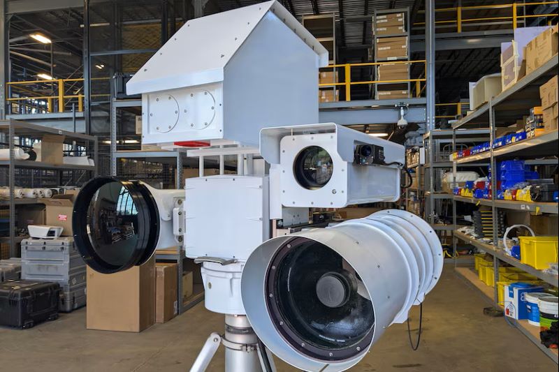
A piece of equipment on a tripod includes three camera lenses.
The new ERSA cameras each have a naked eye-type of view known as an electro-optical visual, as well as an infrared view of the landscape. Made by small tech company Teleidoscope, they're replacing a system that was installed in 2002, which had replaced the initial cameras installed after 9/11.
Wilburn said the new AI-capable cameras are a vast improvement over the legacy system.
"You have an extended range — you can see further. We went from standard definition to high definition. The fidelity is incredible," Wilburn said. "On the infrared side, you have multiple enhanced features like IR colorization. For example, you could utilize a RGB [red, green, blue] filter to where … the object that we're tracking sticks out via heat signature."
A laser range finder allows operators to shoot an eye-safe laser at an object to measure its altitude and distance. There are also some machine-learning elements to the system, such as an enhanced auto-tracking feature that has various locking modes.
"The system itself tries to identify what it believes the target to be, and then the operator can assess whether to override it or fine-tune it," Wilburn said. "The more the feature is used, the better it'll get."
Five men stand around a large camera display on top of a building with a city view in the background.
He said there have been a few growing pains, but that's to be expected.
"The camera itself is amazing. We were able to acquire small targets such as a bird flying all kinds of patterns. It locked onto it and held that lock," Wilburn said. "With the legacies [cameras], you'd have a harder time getting the system to do that."
"You can imagine looking at the camera quality on your iPhone from 2011 to today," said Marine Corps Maj. Nicholas Ksiazek, a Defense Innovation Unit project manager involved in the upgrade project. "Instead of trying to hold steady on the airplane … [operators] are able to spend more time on things that are better suited… like trying to think about what the intent is of the aircraft."
The cameras also integrate a visual warning system, which is a laser that can illuminate the cockpit of an aircraft. The new lasers are used on aircraft that aren't following an assigned flight plan and aren't in radio contact or compliant with the Federal Aviation Administration's special flight rules.
Two cameras are displayed in a warehouse.
"Non-compliant aircraft are aware that, when they see the red-green laser, they need to turn to a heading away from the center of the flight restricted zone, or SFRA, as soon as possible and immediately contact the FAA to try to figure out why they're being sparkled at," Wilburn said, referring to lingo for the visual warning system when it's in use. "There are times that I've used it … and [violators] are responsive to it."
Without that option, military aircraft would have to be deployed to investigate — a much more costly alternative.
Teleidoscope's cameras were tested out by air defense operators during the acquisition process. Two other companies were selected to create prototypes out of commercially developed and available technology. All three systems were installed and tested in 2022.
"They were able to see what worked best in their unique scenario," Ksiazek said.
A view highlights the Lincoln Memorial, the Washington Monument and the Capitol rotunda in the distance.
Wilburn said Teleidoscope's software enhancements were what made its cameras stand out.
"That camera [system] felt like it was an upgrade, versus the other ones [which] were kind of like a refresh," he said.
The Defense Innovation Unit helped Teleidoscope secure funding from the Air Force and the Accelerate the Procurement and Fielding of Innovative Technologies program to quickly field the new camera system.
Two of the new cameras have been installed and are operational. The team is working to install seven new cameras a year going forward.
