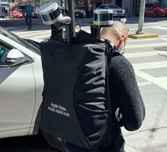
According to the official website of the Maps app, "Apple is driving vehicles around the world to collect data which will be used to improve Apple Maps," but it looks that pedestrians are also being used to map some areas. For now, Apple has only confirmed that this is happening in California.
Last month, the first Apple Maps pedestrian recon teams were spotted in San Francisco. Now, the Cupertino-based giant has confirmed that such teams will be operating in the following areas of California: Alameda County, City and County of Los Angeles, City and County of San Francisco, San Mateo County, Santa Clara County, Santa Cruz County.
This new approach is apparently aimed at improving pedestrian and cycling directions, since Apple Maps users on foot or bike often end up being directed on the same paths as cars. Obviously, this can be annoying, but sometimes it can lead pedestrians and cyclists into dangerous areas.
Apple Maps has been around since September 2012, when it launched as the default map system for iOS. Now available for all Apple operating systems, Apple Maps is still struggling to increase its accuracy. In addition to on-foot data collection, Apple is also using satellite imagery to improve the Maps service. Remains to see how much time they need to finally become a worthy Google Maps alternative worldwide.


